Monday, 25 January 2010

Poads Road to Otaki Forks

On Friday I joined the Wellington Tramping Club for a weekend hike in the Tararua mountains north of Wellington. We drove up on Friday evening stopping for sustenance in the town of Levin. The start point was Poads Road where we camped for the night - just a ground sheet and a fly sheet to keep the rain off.
Up early to begin the tramp - and straight into the Makaretu Stream which we followed for several hours, crossing and recrossing. No paths here! So wet feet all day (standard practice in the Tararuas):


Near the start we entered a gorge where there had recently been a big rock slide. Quite deep here and so we had to wade over waist deep with packs held high!:


Had this little visitor. A weta:

This one hitched a lift on someone's pack and appeared at our next stop. They are big, about 10cm, but harmless:

http://en.wikipedia.org/wiki/Weta

Here we are among lichen covered rocks about to head straight up through the bush to the Oriwa Ridge. We passed a hunter's bivvy (camp and shelter) and saw evidence of the pigs and goats they were after:


It was a hard day, good to be out of the stream, but a tough climb up with 15kg on your back! At the top there was a rainwater collector and a flat area for camping. We moved out of the trees as it was colder there, however in the night the wind got up and we got a bit damp:

Next day wet boots back on (fine after a few minutes) and a tramp along the ridge then down requiring lots of careful navigation using maps, compass, altimeter and a check with the GPS. More stream crossing followed as the waters were high and we had to alter our route:


The day's walk ended 12 hours after leaving our camp! We reached the packed hut at Waitewaewae:
However spaced was made for us and we finally sat down to dinner at about 10pm! Sleeping under a real roof, luxury! Outdoor canine accommdation also provided:

Great tale from a chap about trying to move the toilet building from the old hut site by river rather than carrying it along the muddy track - it promptly sank and had to be hauled out again! The last section of the walk followed an old tramway used to transport logs. The steam engine that was used to haul them down to the rail head still there:


At the very end we crossed the Otaki river on this amazing bridge:


Another good day - only 5 hours of walking and then back to Wellington via a chocolate stop at a garage!

Wading the Makaretu:


Thursday, 21 January 2010

Napier

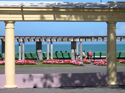
Final stop on the road trip was Napier. In 1931 an earthquake flattened most of the city with ensuing fires causing more damage. Out of the ashes blossomed a planned Art Deco gem. With the town fearful of further quakes nothing rose higher than 2 stories. From Bluff Hill there is a view over the beach and Marine Parade:


More logs!:


A modern sculpture on the seafront:

The A&B building:

NZ flora atop Bluff Hill:

Church and fountain:

Some of the Art Deco facades - at ground level changed to modern shop fronts:


Lots of lovely wooden houses with decks and shady trees, perfect for the warm climate:


On Marine Parade, plenty of benches to relax on and watch the world go by:


Off for weekend hike with the Wellinton Tramping Club this weekend, forecast not great, but hopefully some photos to follow!

Wednesday, 20 January 2010

East Cape

So under grey skies and with my left foot firmly tucked away from the brake (automatic car - tendency to put foot on brake whilst looking for clutch to avoid stalling!) I set off on the inland route Highway 2. Stopped off at Motu to see the falls:

The area has never been logged so a lot of big old trees. It is also a kiwi reserve - 70% of chicks are killed by stoats and a further 25% by cats, dogs and accidents. Before man arrived the only mammals here were bats, so you can see why the kiwis are an endangered species. Bet you didn't know that they can smell worms 3cm under the soil!
The road to the coast winds through the Waioeka Gorge, quite an engineering feat. The soil is poor but that didn't stop settlers trying to run farms. The Tauranga Bridge below is a 'harp' structure built in the 1920s to allow farmers to cross the river. The Maori used the river to travel through the area and Tauranga means 'arrive, alight'.


You have to be able to turn your hand to anything here in New Zealand:


Enjoyed listening to the local radio station, very reminiscent of NECR (especially the missing pets). The bed advert was for a local glazier called Glenn: 'Now and then you do need Glenn'.
Once on the coast I made quite a few stops, like this school at Torere:


Further along there was a macademia nut farm serving fantastic macademia and manuka honey ice cream. The drive way was made of nut shells.
Plenty of views of blue seas and blue skies:


I stayed the night in a cabin at a campsite where there were some wedding celebrations going on (mostly under canvas) in the pouring rain. Had an early night then left before 5 for the 20km drive along an unsealed road to the East Cape lighthouse:

Then several hundred steps to the lighthouse itself and the chance to be one of the first in the world to see the sun on Saturday 16th January 2010!


The drive back revealed the state of the road (and cursory crash barriers):

On the way south glimpses of Mt Hikurangi:


Most Maori communities have a marae or meeting house, this one is in Waipiro:


Just past there I picked up 3 French hitch hikers and they provided company on the drive to Tolaga Bay. They had got involved in the rescue of dozens of pilot whales stranded on the Coromandel Peninsula swimming them out to sea!

A not untypical amount of driftwood on the beach at Tolaga Bay:

One of the big attractions is the 660m long pier, mostly used for recreational fishing now:


Did a 2hr round trip walk to nearby Cook's Cove where the explorer was more successful in obtaining supplies:

The 'hole in the wall' looks through to Tolaga Bay:

Beach and bay:
I dropped the car in Gisborne and took the bus the next day down to Napier.

Gisborne

So here I am in Gisborne (see map from earlier post). A great little town, easy to walk around, the beach and rivers to hand, some nice little shops, cafes etc. A good bookshop where I picked up some work by NZ authors. Tu, by Patricia Grace http://www.kirjasto.sci.fi/grace.htm
is the story of three Maori brothers who enlist in the Maori Battalion in WWII and a great read.


The harbour a busy place with a constant stream of lorries (Twin Peaks style) dropping loads of logs, steaming past a forgotten monument to Captain Cook. This is where he first landed in NZ and 'misunderstandings' lead to the death of a few locals. Not being successful in getting fresh supplies Cook named the area Poverty Bay!


Some boats aren't going anywhere fast:


The museum featured a section of a ship rescued from a wreck. It shut at 4pm so didn't get much time in there!

This monument is a representation of the prow of a waka or ocean going canoe that the Maori arrived on from other Polynesian Islands http://en.wikipedia.org/wiki/M%C4%81ori_migration_canoes
The figure at the top is Tangaroa, God of the sea. The one at the bottom is Maui, half man and half god.

The weather here is generally the warmest in NZ, getting up to 30 degrees this week.


The person to spot land on Cook's ship the Endeavour in 1769 was Young Nick the cabin boy (press ganged into service of course).


Modern canoes were being paddled at speed up and down the rivers, mostly out-riggers like the waka of old.

I spent a couple of nights in the YHA just across the river from the town centre.

Next I hired a car and set off inland on Highway 2 then round the East Cape on scenic Highway 35.