Sunday, 21 February 2010

Tongariro

On Friday we set off in the car for Tongariro National Park about 4 hours drive north of Wellington. Stopped for food along the way. Unfortunately the DC3 cafe in Mangaweka was closed!:

We stayed the night at the Whakapapa Holiday Camp and joined the throngs the next morning heading for the 17km Tongariro Crossing - one of NZ's most popular walks. Early on the cloud raced in to catch us:


But it soon receded. Here in the south crater we made the two hour (90 mins up but only 25 down!) side trip to the summit of Mt Ngauruhoe (na ra hoe ay). At 2291m it is a climb of over a 1000m from the start of the walk:

From the volcanic scree slopes there were fantastic views over the south crater to Tongariro itself (1967m) and the Blue Lake:


Ngauruhoe is the mountain which featured as Mt Doom in the Lord of the Rings. "Oh no Mr Frodo sir, I've lost the ring!":


Looking east over the volcanic landscape (it's been quiet here for 15 years):

The Red Crater and beyond:


The Emerald Lakes, the colour comes from minerals leaching down from the Red Crater:

Snow on Mt Ruapehu. The 2797m peak was visible from Taranaki 80 miles away (and vice versa today). Ngauruhoe in the middle with the Red Crater in front and the ridge path to the right leading down past the Emerald Lakes to the central crater:


The final leg of the crossing descends past the Ketetahi Springs with views over Lakes Rotoaira and Taupo:

I can tell you it was an early night after that walk! We managed it in 8 hours.
Drove back to Wellington the next day in time to see the Phoenix in a dramatic penalty shoot out win over Perth in the soccer league play-offs first round.
Tomorrow I fly to Stewart island in the very south of the country. I will be away 3 weeks but hope to make some posts as I go.

Tuesday, 16 February 2010

Taranaki

On Friday we headed north and west to the Taranaki area dominated by the 2518 m high mountain of the same name (also known as Mt Egmont):

It stood in for Mt Fuji during the filming of the Tom Cruise film The Last Samurai. Tara means mountain and naki shining - due to the snow in winter. It is one of the most symmetrical volcanic cones in the world and was last active only 150 years ago. Egmont National Park extends out several miles from the base of the mountain and is hemmed in by rich farmland:

Read here about the legend of its formation:
On the lower slopes there are various short walks like this one to Wilkie's Pools near Dawson's Falls:
From there I took the high level round the mountain circuit. Here passing a ski area below the Shark's Tooth (2510m):

I spent the night in Maketawa Hut at 1074m and left at first light:

Snow-capped Mount Nguaruhoe in Tongariro National Park just visible to the left above the clouds with Ngauruhoe the cone shape to the left:

Scenes from The Lord of the Rings were shot in Tongariro with Mt Ngauruhoe standing in as Mt Doom:

Just for a few minutes the rising sun caught the mountain:

From the hut it was a 4 hour walk to the top. Very steep. A large section is across scoria slopes (areas of volcanic gravel) and tricky to walk on. A stout stick was my constant companion! At the top I reached the crater still filled with ice and snow and a view down to the Dawson Falls Centre. The Shark's Tooth on the left:

Proof I made it to the summit. The plaque celebrates the first recorded climb in 1839. The mountain was sacred to the Maori, and said to have once lived in the centre of the island feeling here after defeat in a battle with Tongariro.

Leaving the top before 11am I met plenty of people on their way up including Dept. of Conservation staff replacing the track markers (many had gone or been heavily weathered). Here you can see the boulders leading to the scoria slopes with cloud surrounding the mountain at about 1400m (the height of Ben Nevis):

Once in to the cloud it began to rain and after retieving my gear from the hut I left the park for a nice hot shower! Back to Wellington tomorrow then on to try the Tongariro Crossing at the weekend.


Thursday, 11 February 2010

Nelson

My base for a couple of days either side of the Heaphy track was in Nelson. Quite a busy but relaxed little town. Also a big retirement area, probably due to the mild climate. I walked up the hill for this view of the town and port. It has a unique natural boulder bank extending several miles out from the shore:


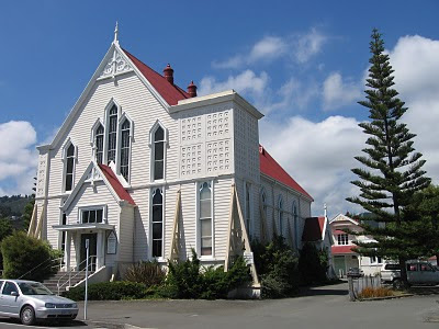
Church:


One day there were some acrobats giving a streeet show:


There was a loose story about a sailing ship adrift - masts to be climbed, sails to slide down and a trapeze. Pretty incredible stuff and entertaining for the school kids who had come to watch (note compulsory sunhats):


Lots of nice spaces to sit outside and eat or drink, warm enough for t-shirt even after dark:


Before leaving Nelson I went for a half day kayak trip from nearby Cable Bay. Through caves and between big rocks:


Plenty of wildlife. Cormorants, shearwaters, terns, this southern fur seal and even a tiny blue penguin that popped up right in front of me:


We stopped at a beach for some snorkelling where I saw tiny jellyfish the size of my thumbnail and lots of amazing beach pebbles:

Off to Taranaki this weekend.

The Heaphy Track

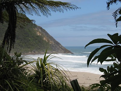
The Heaphy Track is one of NZ's Great Walks so well maintained, marked and quite busy. However I seemed to be walking the opposite way to most people and though I passed a few others it seemed fairly quiet. The first day was mainly along the shore with views like this:


And this:


Quite a few river crossings, but kept my feet dry:


An incredible amount of driftwood, washed down the rivers and into the sea by the several metres of rain on the West Coast, is heaped on the beaches:


Some lovely stones too:


Looks like this one has been replanted:


The Heaphy Hut, reached after about 5 hours walking. A lovely spot with a nice wide river estuary to swim in and escape the sandflies. Hut was full with a wide range of nationalities from Sweden, Germany, NZ, Italy and Israel:


A lovely beach to walk on. If you keep moving the flies don't seem to find you. The bites however itch for days! A fantastic sunset:


The next morning the path followed the Heaphy River, through areas of limestone and in the shade of palms:


In the afternoon the track began a long, gentle uphill. Along the way some track art:


That night I was alone at Mackay Hut:

From the terrace great views, all the way down to the beach and river mouth (just visible towards the right of the picture). That night clear skies and an incredibly starry sky.


Me and my shadow. Set off in the sunshine again along a mostly level but very hardpacked track which left my feet aching.


Occasional views on the first part of the day through the trees to the hills:


Some colour along the way:


One of the reasons for the original track was to access pastures for a possible sheep station. In the end it wasn't considered suitable, but the area is known as Gouland Downs:


The creeks and streams along the way had interesting names like Deception, Monument and Blue Shirt - makes you wonder what happened there. Did someone find/lose the shirt or was it worn on the day of discovery? Looks like by the time they got to this river they had run out of ideas:


Where old boots go to die:

The last hut was at Perry Saddle, busy once again with people beginning the tramp including a guided trip.

With little cloud I headed up nearby Mt Perry (1238m) despite 7 hours of walking already that day. It was worth the steep 45 minute climb for the views at the top:

After that I took a plunge in the freezy pool of a nearby river, very refreshing! Heard kiwis that night but didn't see any. Thought I was doing well but met an Aussie couple who had walked 40km that day (the track is only about 60km in total!), the hut was full so they hiked another 10k down to the hut at the end of the track that evening.

The next day left with the dawn to head downhill for 4 hours to meet the bus. We stopped at this famous old store for a drink. Like a living museum complete with post office:


Got back to Nelson in the afternoon.